|
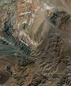
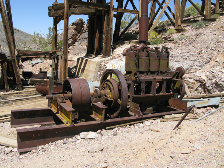
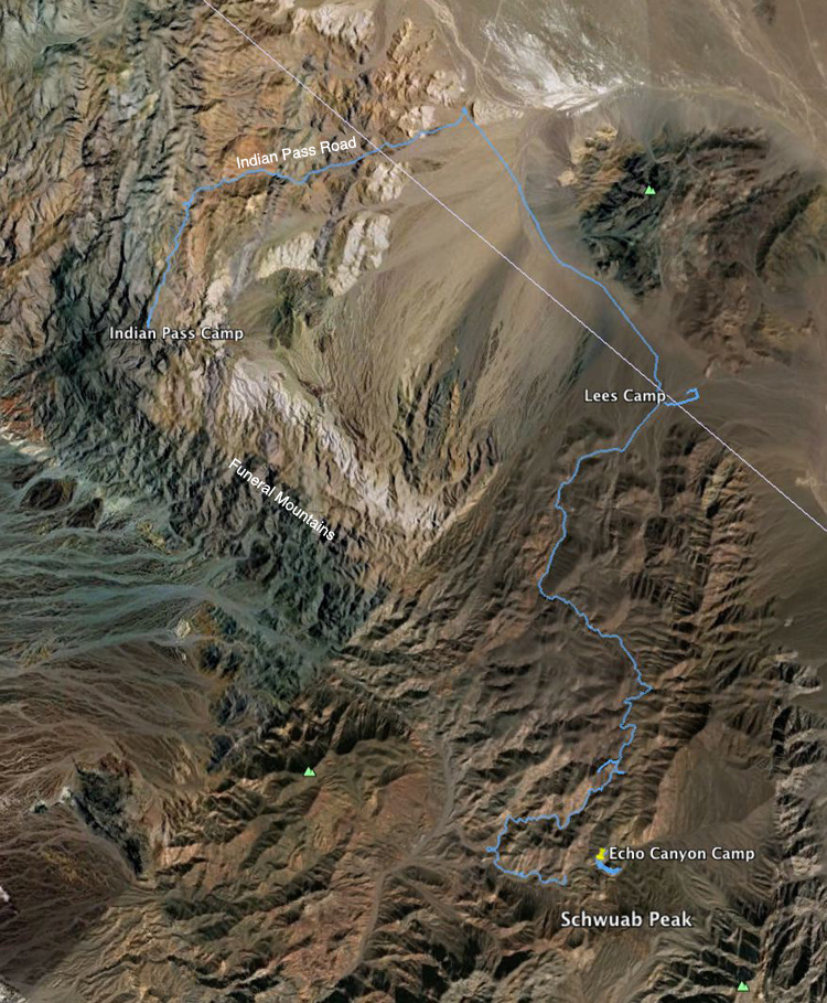
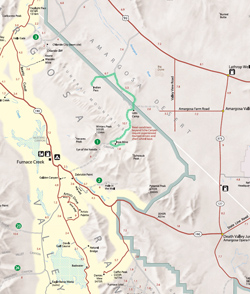 We were up at 6:40 am and had an eggs and sausage breakfast. Just before 11:00 am we started driving back down the Inyo Mine Road, stopping in a few minutes to visit Inyo Mine. We were up at 6:40 am and had an eggs and sausage breakfast. Just before 11:00 am we started driving back down the Inyo Mine Road, stopping in a few minutes to visit Inyo Mine. 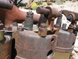 We had thoroughly explored the mine workings on a previous trip, and since we had a (presumably) scary road ahead of us, we only spent about 20 minutes this time, admiring the machinery and the shafts covered with wire mesh to keep people from jumping. By 11:33 am we were back at the intersection of the Echo Canyon Road, where we turned right to continue the slow ascent of Echo Canyon to the north. We had thoroughly explored the mine workings on a previous trip, and since we had a (presumably) scary road ahead of us, we only spent about 20 minutes this time, admiring the machinery and the shafts covered with wire mesh to keep people from jumping. By 11:33 am we were back at the intersection of the Echo Canyon Road, where we turned right to continue the slow ascent of Echo Canyon to the north.

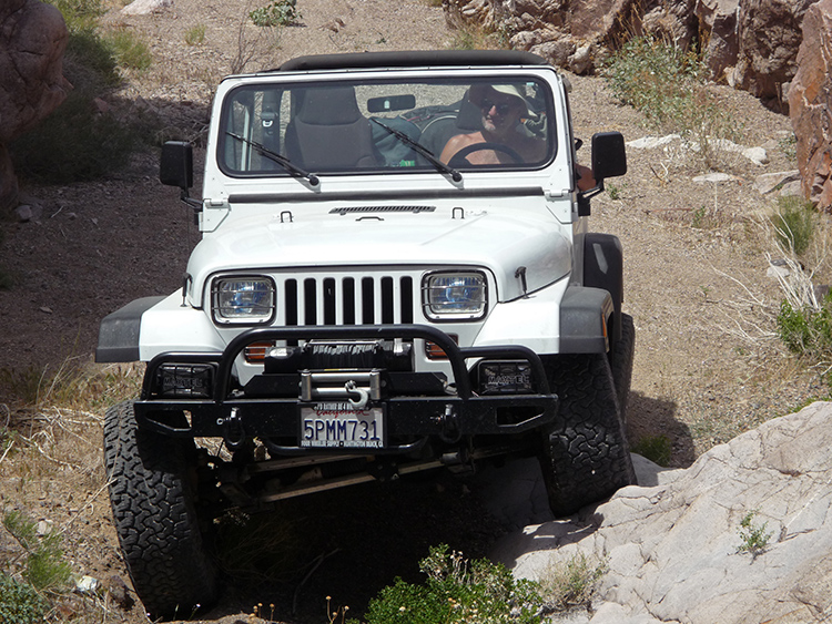
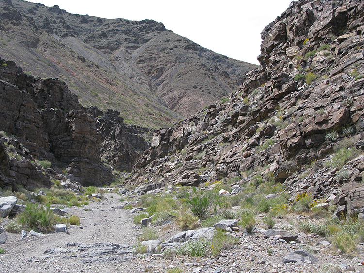
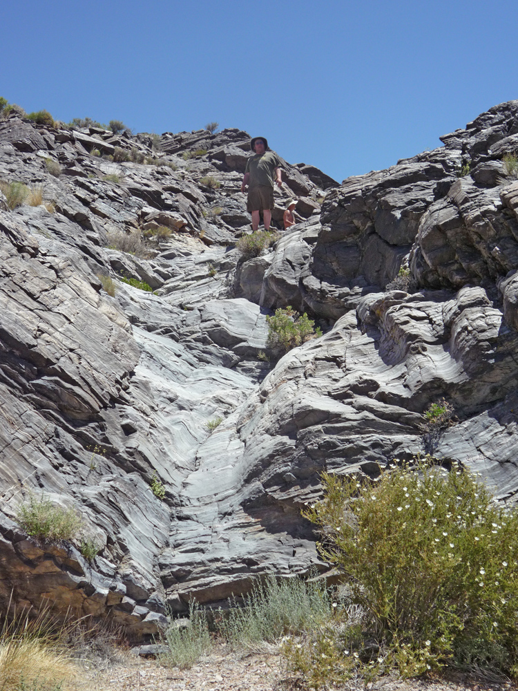
Along the way we found an area with extremely thin flakes of shale, almost sharp enough to shave with. At 12:20 pm, 3.1 miles after the intersection, we encountered the first dry fall. It looked rough, and my Wrangler took two tries to get up, but it was still not as bad as I read in the literature (that it might cause vehicle damage and likely require a winch). Joey made it up on the first try . .
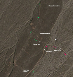
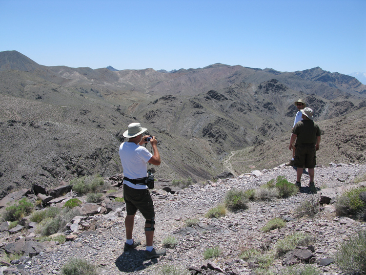
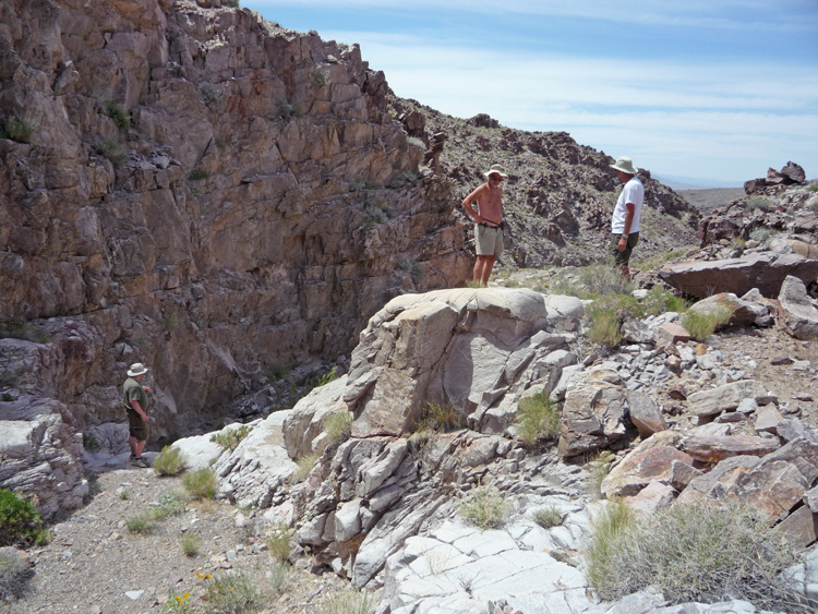
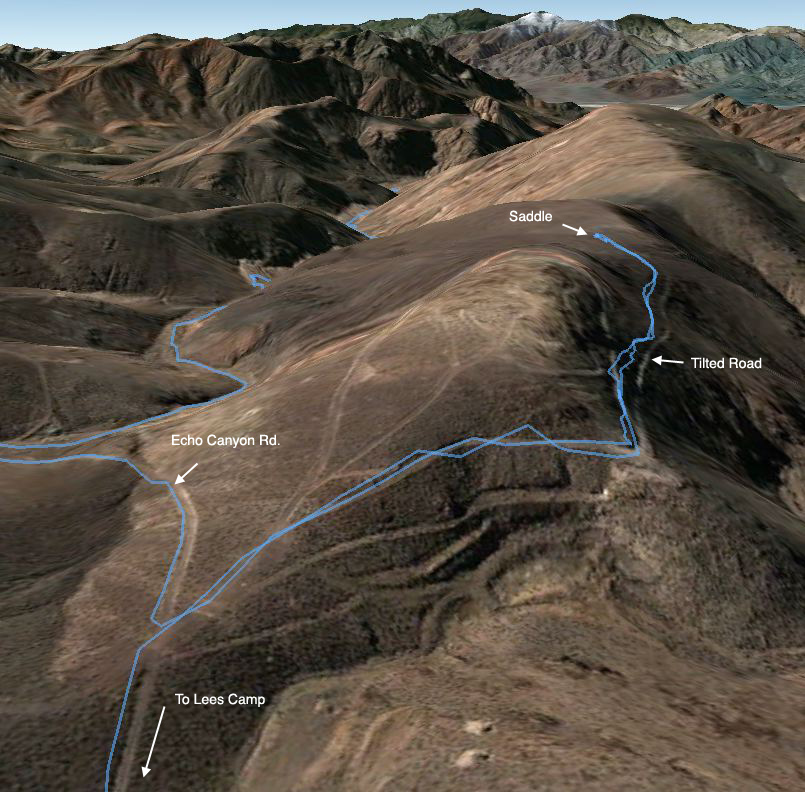
 A few minutes after the dry fall, at 12:33 pm, we turned on a short 500' spur to the right, and took a 10 minute walk up a smooth dry fall. Back on the main road, we drove another 0.2 miles where I decided to take a much longer spur to the left to some mines that I saw in the aerial photos. We were in fairly high country now, about 4600' (same as the Amargosa Lookout). Most views from this point were looking down into valleys, some of them steep. The spur road turned out to be amazingly harrowing A few minutes after the dry fall, at 12:33 pm, we turned on a short 500' spur to the right, and took a 10 minute walk up a smooth dry fall. Back on the main road, we drove another 0.2 miles where I decided to take a much longer spur to the left to some mines that I saw in the aerial photos. We were in fairly high country now, about 4600' (same as the Amargosa Lookout). Most views from this point were looking down into valleys, some of them steep. The spur road turned out to be amazingly harrowing —much scarier than the Echo Canyon Road. It was neither challenging nor steep, but it traversed a steep slope with a killer drop-off on the right, combined with significant downhill lean. Rather than being cut into the slope, the road was built up with rock on the downhill side, and it was not clear how stable those rocks were. To avoid leaning too much we had to drive with the right wheels on the edge, and even then the tilt was uncomfortable. —much scarier than the Echo Canyon Road. It was neither challenging nor steep, but it traversed a steep slope with a killer drop-off on the right, combined with significant downhill lean. Rather than being cut into the slope, the road was built up with rock on the downhill side, and it was not clear how stable those rocks were. To avoid leaning too much we had to drive with the right wheels on the edge, and even then the tilt was uncomfortable.
 After just ¼ mile of this I decided it wasn’t going to end soon and it was too scary to keep going. However there was no immediate place to turn around, so we had to continue the tilty drive. I knew from the map that there was a saddle (level spot) coming up in After just ¼ mile of this I decided it wasn’t going to end soon and it was too scary to keep going. However there was no immediate place to turn around, so we had to continue the tilty drive. I knew from the map that there was a saddle (level spot) coming up in 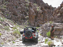 0.2 miles and I hoped we would find a place to turn around there. Sure enough, there was an easy turnaround at the saddle, where the road forked to go around either side of the next hill. As long as we were stopped here, I suggested we get out and walk a little further down the left fork just to see what it looked like. From this saddle we could look back at the Echo Canyon Road we had just come up. We only walked about 100' before deciding it wasn’t going to change soon, and time was getting short. 0.2 miles and I hoped we would find a place to turn around there. Sure enough, there was an easy turnaround at the saddle, where the road forked to go around either side of the next hill. As long as we were stopped here, I suggested we get out and walk a little further down the left fork just to see what it looked like. From this saddle we could look back at the Echo Canyon Road we had just come up. We only walked about 100' before deciding it wasn’t going to change soon, and time was getting short.
It was now 1:05 pm and we had a lot of distance to cover, and there was supposed to be another serious dry fall descent on the other side of the high point of Echo Canyon Road. We first had to return to the main road by going back 0.4 miles on this tilty spur road, which I was not thrilled about. It was pretty scary going back, but it took us only 8 minutes to return to the Echo Canyon Road. The Echo Canyon Road then continued up and down several times as we headed generally north, and the going was not very difficult. Our high point of the road, though not very obvious, was at 4840'. 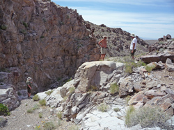 The waterfall on the descent was at 3.1 miles from that spur, which we reached at 2:00 pm. It didn’t look as bad as the one going up, and this time, going down, gravity made it easier. Still, we needed a spotter for each jeep and we spent almost a half hour there. The waterfall on the descent was at 3.1 miles from that spur, which we reached at 2:00 pm. It didn’t look as bad as the one going up, and this time, going down, gravity made it easier. Still, we needed a spotter for each jeep and we spent almost a half hour there.
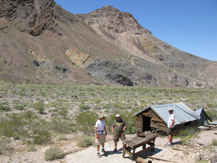
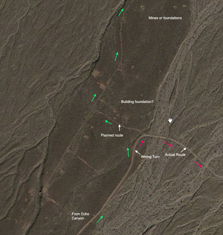
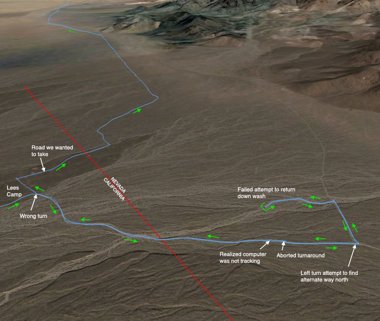
 At 2:27 pm we continued our gradual descent in the canyon. Around 3:00 pm we left the canyon and entered relatively flat open desert, and within 5 minutes reached the area of Lees Camp. There wasn’t much visible except some small ruins, but I knew from documentation and aerial photos that there was a lot to see here, including numerous mine shafts. I would have liked to look around, but it was getting late enough now that we needed to find a campsite, and I had decided that a good place for our last night was the end of the road at Indian Pass, still a considerable drive. I was worried all along that navigation would be a little difficult around here. Somewhere in the Lees Camp area I new we needed to turn left on an obscure road whose position was not clear from the maps. I wasn’t even sure if we had to go into Nevada first, a fraction of a mile past Lees Camp. Google Earth’s aerial photos showed a patchwork of roads, but none seemed to correspond to any maps. I had one route picked out that involved a left turn while still in California that seemed to connect to our desired route. At 2:27 pm we continued our gradual descent in the canyon. Around 3:00 pm we left the canyon and entered relatively flat open desert, and within 5 minutes reached the area of Lees Camp. There wasn’t much visible except some small ruins, but I knew from documentation and aerial photos that there was a lot to see here, including numerous mine shafts. I would have liked to look around, but it was getting late enough now that we needed to find a campsite, and I had decided that a good place for our last night was the end of the road at Indian Pass, still a considerable drive. I was worried all along that navigation would be a little difficult around here. Somewhere in the Lees Camp area I new we needed to turn left on an obscure road whose position was not clear from the maps. I wasn’t even sure if we had to go into Nevada first, a fraction of a mile past Lees Camp. Google Earth’s aerial photos showed a patchwork of roads, but none seemed to correspond to any maps. I had one route picked out that involved a left turn while still in California that seemed to connect to our desired route.
But while we were driving past Lees Camp I suddenly realized that our current position on the map on my laptop hadn’t been updated for the last 10–15 minutes. This was our one and only computer glitch of the trip, and as luck would have it, it malfunctioned just when we needed to turn. When I got it fixed, our position jumped ahead to a point in Nevada that was 0.4 miles beyond that left turn.
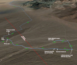 I decided we needed to go back, so Bobby and Joey stopped their jeep while Danny and I turned around. This was difficult because the road was so narrow, and after a multi-point turn we were pointed in the reverse direction. But we went only about 60' when I realized that there was another left turn we could have taken, if we had kept driving just 0.1 miles further, that would intersect a wash that had a parallel road in it that would take us back to where we wanted to go. I decided, rather than making Joey turn around his big jeep here, we would try that route, so Danny and I turned around again and we all kept going another 0.1 miles to that second turn. I decided we needed to go back, so Bobby and Joey stopped their jeep while Danny and I turned around. This was difficult because the road was so narrow, and after a multi-point turn we were pointed in the reverse direction. But we went only about 60' when I realized that there was another left turn we could have taken, if we had kept driving just 0.1 miles further, that would intersect a wash that had a parallel road in it that would take us back to where we wanted to go. I decided, rather than making Joey turn around his big jeep here, we would try that route, so Danny and I turned around again and we all kept going another 0.1 miles to that second turn.
That second left turn, which looked good on Google Earth, was a very obscure and slow road. Three minutes into it we got to the wash, but there was no obvious road in the wash to take us back. It was drivable though, so we went down it for about 4 minutes until it got so bad and slow, I decided it was not going to save us any time to continue on this way, and there was a risk of getting to a total impasse. It was 3:25 now, so we turned around to retrace our steps back to find the original intersection in Lees Camp, which we reached in 10 minutes.
 For the next 30 minutes we drove northwest 5.5 miles in a nearly straight line in very open country across a portion of the Amargosa Desert. At an average speed of 11 mph, it was a pretty good clip. There were interesting hills and buttes to the east and dead ahead. Almost adjacent to one of these buttes, we reached the intersection of the Indian Pass Road at 4:05 pm. For the next 30 minutes we drove northwest 5.5 miles in a nearly straight line in very open country across a portion of the Amargosa Desert. At an average speed of 11 mph, it was a pretty good clip. There were interesting hills and buttes to the east and dead ahead. Almost adjacent to one of these buttes, we reached the intersection of the Indian Pass Road at 4:05 pm.
We turned left (west) onto the Indian Pass Road. We were still in Nevada, but in 6½ minutes we reached the California border again, which was also the border to the National Park. The road was ascending very gradually with easy driving back to the Funeral Mountains. 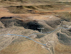 About a half hour on the Indian Pass Road, I realized we had missed a left (south) turn near a wash and were going east instead, back up a slope. I didn’t think we were more than 500' beyond the turn. We turned around and drove slowly, looking for a road near the wash headed south, but after 1000' we still didn’t see it. The road was plainly visible on Google Earth, except for its intersection with the road we were on, which was confused because it went right into the wash. Looking ahead though, down the wash, I could see the road we wanted on the raised side of the wash, so we turned around again and just headed into the wash, hoping we would find a way to get up to the road. About a half hour on the Indian Pass Road, I realized we had missed a left (south) turn near a wash and were going east instead, back up a slope. I didn’t think we were more than 500' beyond the turn. We turned around and drove slowly, looking for a road near the wash headed south, but after 1000' we still didn’t see it. The road was plainly visible on Google Earth, except for its intersection with the road we were on, which was confused because it went right into the wash. Looking ahead though, down the wash, I could see the road we wanted on the raised side of the wash, so we turned around again and just headed into the wash, hoping we would find a way to get up to the road.
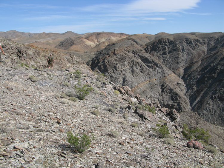
In only a few hundred feet down the wash we found an easy route a little uphill of that road, and we continued with fairly easy driving, descending slightly in more open country, for the next 2 miles. 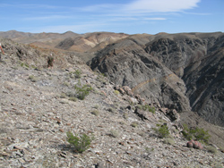 On the way, we saw 4 curious rock cairns about 5' high set up in a flat area as if goal posts for a soccer field. At 4:48 we reached the edge of a precipice near Indian Pass with an impressive 1000' drop into Indian Pass Canyon and wide open views in all directions, down into Death Valley to the west. We stopped briefly at the first lookout, and ten drove a few feet further as the road continued along the precipice, to the end of the drivable road. The actual point named Indian Pass was probably the summit of a trail up to this elevation from the bottom of Indian Pass Canyon, at the end of the canyon a fraction of a mile east of here. On the way, we saw 4 curious rock cairns about 5' high set up in a flat area as if goal posts for a soccer field. At 4:48 we reached the edge of a precipice near Indian Pass with an impressive 1000' drop into Indian Pass Canyon and wide open views in all directions, down into Death Valley to the west. We stopped briefly at the first lookout, and ten drove a few feet further as the road continued along the precipice, to the end of the drivable road. The actual point named Indian Pass was probably the summit of a trail up to this elevation from the bottom of Indian Pass Canyon, at the end of the canyon a fraction of a mile east of here.
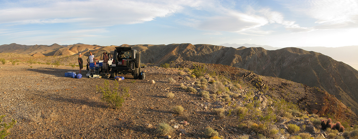
But this was clearly the end of the road and we would need to camp in this area, so we decided to go back to the stop by the first precipice. It was rather windy, but there wasn’t any sheltered place to camp, so we set up the jeeps at right angles to make an enclosed area to protect our kitchen from the wind.

  By 5:30 we were chugging tequila directly out of the bottle (I'm not sure why—were we out of margarita mix?) and eating Trader Joe’s marinated mushrooms with garlic. Dinner was chili with corn, onion, cheddar cheese, jalapenos (of course) and some salsa to thin out the mixture so we could heat it. We had it on hamburger buns open faced. By 5:30 we were chugging tequila directly out of the bottle (I'm not sure why—were we out of margarita mix?) and eating Trader Joe’s marinated mushrooms with garlic. Dinner was chili with corn, onion, cheddar cheese, jalapenos (of course) and some salsa to thin out the mixture so we could heat it. We had it on hamburger buns open faced.
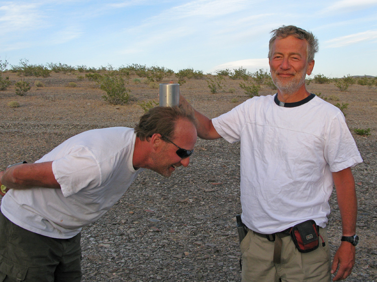
 We were done eating around 7:30 pm and 15 minutes later we We were done eating around 7:30 pm and 15 minutes later we 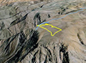 took a little evening stroll around the area, walking further along the precipice than we could drive and then back to camp in a loop. The round trip was 45 minutes and under ½ mile, but half of that time was spent on the knoll above the campsite. I’m not sure what we did there—perhaps some Frisbee. took a little evening stroll around the area, walking further along the precipice than we could drive and then back to camp in a loop. The round trip was 45 minutes and under ½ mile, but half of that time was spent on the knoll above the campsite. I’m not sure what we did there—perhaps some Frisbee. 
|


