|
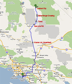 We got up at 3:00 am, but Morrie didn’t sleep too well past midnight. With the help of some wiggly, we left the house at 4:07 am, in constant communication using my new walkie talkies (aka “runnie screamies”). At 5:05 am when we were about to turn onto I-15, there was a detour due to exit ramp work. When I slowed down to get off the ramp, my engine check light came on. Somewhat worried, I pulled over and lifted the hood to see if there was anything obvious going on in the engine. But I saw nothing wrong, and my gauges (oil pressure, temperature) were normal. The detour forced us into a messy maneuver on side streets in the dark. Then after getting back on the highway, distracted and concerned about the engine check light, I wasn’t paying attention to the signs and got off on the I-10 east ramp by mistake, so we got off at the first exit, which unfortunately didn't have an entrance ramp going back the way we came. So with GPS assist we threaded our way through more side roads in an industrial area to find the highway again. Total cost of detour+error was 15 minutes. That doesn’t seem like a lot but every minute lost when getting up at 3:00 am feels like a waste. We got up at 3:00 am, but Morrie didn’t sleep too well past midnight. With the help of some wiggly, we left the house at 4:07 am, in constant communication using my new walkie talkies (aka “runnie screamies”). At 5:05 am when we were about to turn onto I-15, there was a detour due to exit ramp work. When I slowed down to get off the ramp, my engine check light came on. Somewhat worried, I pulled over and lifted the hood to see if there was anything obvious going on in the engine. But I saw nothing wrong, and my gauges (oil pressure, temperature) were normal. The detour forced us into a messy maneuver on side streets in the dark. Then after getting back on the highway, distracted and concerned about the engine check light, I wasn’t paying attention to the signs and got off on the I-10 east ramp by mistake, so we got off at the first exit, which unfortunately didn't have an entrance ramp going back the way we came. So with GPS assist we threaded our way through more side roads in an industrial area to find the highway again. Total cost of detour+error was 15 minutes. That doesn’t seem like a lot but every minute lost when getting up at 3:00 am feels like a waste.
Going over the mountain passes north of the Los Angeles basin on the drive north, my fully loaded jeep (which was carrying both coolers and 120 lbs of ice), wouldn’t go over 40 mph. But for most of the rest of the trip I could maintain 55-60 mph, which was fine by me. At 6:47 am, at an hour past dawn and after 2.5 hours of driving (not counting the detours), we got to the Roadhouse Restaurant at “beautiful” Kramer Junction, also known as Four Corners, at the intersection of 395 and 58. Breakfast was great, and the stop took 55 minutes. When I started my jeep again at the restaurant, the engine check light was off—what a relief! The light didn’t come back on for the rest of the trip. A few minutes later at 7:58 am we had our first “cheap-ass” (non-Macanudo cigar). Our next destination was Trona in Searles Valley, about 60 miles away, the last town and gas station before Death Valley.
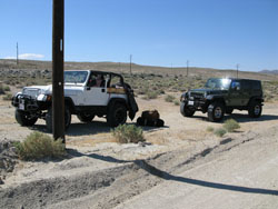 About an hour later, at 8:49 am, on the portion of CA 178 also called the Trona Rd. between U.S. 395 and Trona, we reached a dirt side road About an hour later, at 8:49 am, on the portion of CA 178 also called the Trona Rd. between U.S. 395 and Trona, we reached a dirt side road at the top of Poison Canyon. This road was recommended to me by David Wright (a former resident of the Death Valley area) as a nice out-of-the-way diversion off the highway for the last 11 miles to Trona. Probably the maintenance road for a buried gas line, the road disappeared into the hills on our left, remaining high while CA 178 went down into Poison Canyon. A couple of minutes into this dirt road we stopped to air down our tires and release the sway bars, a messy, greasy operation on my jeep (Joey’s is a pushbutton). Oh yes—we also consumed our first beer. at the top of Poison Canyon. This road was recommended to me by David Wright (a former resident of the Death Valley area) as a nice out-of-the-way diversion off the highway for the last 11 miles to Trona. Probably the maintenance road for a buried gas line, the road disappeared into the hills on our left, remaining high while CA 178 went down into Poison Canyon. A couple of minutes into this dirt road we stopped to air down our tires and release the sway bars, a messy, greasy operation on my jeep (Joey’s is a pushbutton). Oh yes—we also consumed our first beer.
Releasing my sway bar was harder than it had to be, only because I kept trying in vain to replace a washer (needed when the sway bar is normally attached) onto the holding stud, rather than just keeping it off because it’s not needed anyway while disconnected. I eventually decided to wrap the greasy washer in a paper towel and save it in the hand cleaner bag (a clever location which I was to forget a week later).
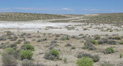 From prior experience I knew that deflating tires takes amazingly long if you do them one at a time. To speed this up, I brought 4 home-made tire deflators made of finishing nails, so together we could do all the tires of a jeep at once. Even with us all working simultaneously, the whole process, sway bar, tires and beer, still took 45 minutes. While doing this I noticed a whitish salt flat just off to the left (northwest), so we decided to try our first round of Frisbee here as well. From prior experience I knew that deflating tires takes amazingly long if you do them one at a time. To speed this up, I brought 4 home-made tire deflators made of finishing nails, so together we could do all the tires of a jeep at once. Even with us all working simultaneously, the whole process, sway bar, tires and beer, still took 45 minutes. While doing this I noticed a whitish salt flat just off to the left (northwest), so we decided to try our first round of Frisbee here as well.
Frisbee lasted a little under an hour, after which we needed a second beer. Crushing used beer cans under foot is mandatory on Greenshit trips to keep the garbage volume under control, and there is an ongoing competition to see who could do the best crush. The crush score is a measure of the percentage of the surface areas of the two ends of the can that overlap. This morning Joey hit one so exact it rated a 95, possibly a record for this trip.
At 10:52 am (a total stop of 2 hours) we were back on the gas line road, which kept going nearly straight, parallel to but out of sight of the highway that was about 2 miles to the south. As we hoped, it felt remote, with impressively slow driving. (Looking at David Wright’s email later, there may have been another side road from here into the hills and another canyon that we could have explored.) A half hour later, we stopped briefly to look at a wide and deep gully near the road, that went back in the direction we came. 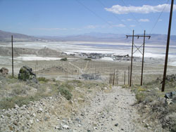 In another half hour, around 11:45 am at a high point, we saw the Searles Valley and the Trona region ahead of us, a jumble of power lines and an industrial complex built to harvest minerals from the mostly dry Searles Lake. We were just outside of Westend, the first of series of towns or suburbs strung out along the Trona Road for the next few miles, with houses and a few stores between the processing plants. The next town a minute or two down the highway was South Trona, and 3 minutes later we pulled into what we thought was our old gas stop in the third town, Argus. But the gas station didn’t look familiar, so we decided to keep driving. A couple minutes after that we got to another gas station in Trona proper. While that still wasn’t the old gas station we were seeking, we stopped anyway to top off the gas, as we figured (I think correctly) that this was our last opportunity before Death Valley. Total gas-up time was just 10 minutes. In another half hour, around 11:45 am at a high point, we saw the Searles Valley and the Trona region ahead of us, a jumble of power lines and an industrial complex built to harvest minerals from the mostly dry Searles Lake. We were just outside of Westend, the first of series of towns or suburbs strung out along the Trona Road for the next few miles, with houses and a few stores between the processing plants. The next town a minute or two down the highway was South Trona, and 3 minutes later we pulled into what we thought was our old gas stop in the third town, Argus. But the gas station didn’t look familiar, so we decided to keep driving. A couple minutes after that we got to another gas station in Trona proper. While that still wasn’t the old gas station we were seeking, we stopped anyway to top off the gas, as we figured (I think correctly) that this was our last opportunity before Death Valley. Total gas-up time was just 10 minutes.
After Trona, the Trona Road becomes the Trona-Wildrose Road because it eventually goes to the Wildrose area of the national park by the Charcoal Kilns. On the way, this paved road passes north over the Slate Range and down into the southern half of Panamint Valleyy. A half hour from Trona we reached the Slate Range Crossing , the 2930' pass in the Slate Range between Searles Valley and Panamint Valley. From here the Trona-Wildrose Road drops about 1000' in a long, impressive switchback into Panamint Valley, with outstanding views on the way. But for the once, we weren’t going down that way. Instead, we turned off to the right (east), exactly at the top of the pass, onto a dirt crossroad known as the old Remi Nadeau “Shotgun” Road. , the 2930' pass in the Slate Range between Searles Valley and Panamint Valley. From here the Trona-Wildrose Road drops about 1000' in a long, impressive switchback into Panamint Valley, with outstanding views on the way. But for the once, we weren’t going down that way. Instead, we turned off to the right (east), exactly at the top of the pass, onto a dirt crossroad known as the old Remi Nadeau “Shotgun” Road. 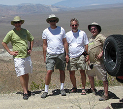 Nadeau was a French Canadian who did development in the Owens Valley area (see Nadeau’s story). This was Nadeau’s freighting road between Indian Wells (a small town on the other side of Ridgecrest, and Lookout City where we were headed). A small road sign here also calls it China Road, presumably because of the Chinese sleeping circles about 1 mile and a 25 minute drive to the east where we were headed, at an elevation a few hundred feet below the Slate Range Crossing. Here, Chinese road builders, employed by Nadeau to build this road in the 1870’s, made stone shelters as protection from the wind. There are supposedly about 30 of these circles in a flat area, all with openings to the northeast to keep out wind, and skillfully built (originally—now they are pretty run down). However, I estimated we saw only 15 of them. Most were only big enough for one person, but some could hold a family. Nadeau was a French Canadian who did development in the Owens Valley area (see Nadeau’s story). This was Nadeau’s freighting road between Indian Wells (a small town on the other side of Ridgecrest, and Lookout City where we were headed). A small road sign here also calls it China Road, presumably because of the Chinese sleeping circles about 1 mile and a 25 minute drive to the east where we were headed, at an elevation a few hundred feet below the Slate Range Crossing. Here, Chinese road builders, employed by Nadeau to build this road in the 1870’s, made stone shelters as protection from the wind. There are supposedly about 30 of these circles in a flat area, all with openings to the northeast to keep out wind, and skillfully built (originally—now they are pretty run down). However, I estimated we saw only 15 of them. Most were only big enough for one person, but some could hold a family.
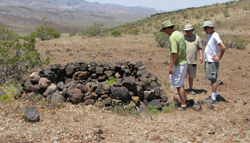 We spent 15 minutes looking at these We spent 15 minutes looking at these 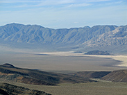 circles and admiring the view of Panamint Valley and the perfectly straight dirt road that continued to infinity in the north, which we were about to descend. We left the sleeping circles at 1:11 pm. Still descending the Slate Range, we reached the start of that “straight” section of road that we saw from above, six minutes later at the 2200' elevation. At 1:25 pm, still gradually descending, we crossed Water Canyon Wash circles and admiring the view of Panamint Valley and the perfectly straight dirt road that continued to infinity in the north, which we were about to descend. We left the sleeping circles at 1:11 pm. Still descending the Slate Range, we reached the start of that “straight” section of road that we saw from above, six minutes later at the 2200' elevation. At 1:25 pm, still gradually descending, we crossed Water Canyon Wash at the bottom of the Slate Range. It was dusty, dry and rather wide, and the banks were cut to make it easy to get in and out of it, but I heard that if there had been significant spring melting in the mountains or a recent thunderstorm, this crossing could have been impassable. at the bottom of the Slate Range. It was dusty, dry and rather wide, and the banks were cut to make it easy to get in and out of it, but I heard that if there had been significant spring melting in the mountains or a recent thunderstorm, this crossing could have been impassable.
There was another side road into the Slate Range that we could have taken if we wanted to camp there tonight, but I would save that for another time. It was only 1:30 pm, and we had until at least 4:00 pm to find a campsite, according to our lazy schedule. My goal was to camp at Lookout City on the top of Lookout Mountain, at the base of the Argus Range along the west border of Panamint Valley. We could see the mountain from here, and it seemed like we would have plenty of time to get there.
At 1:34 pm our dirt road brought us back to the Trona-Wildrose Rd., but it went right across and continued perfectly straight on the other side. According to the GPS map and also Google maps, this section of the road is called “Hadue”. However, after a subsequent discussion with David we decided this was just a mistake—a misspelling/corruption of Nadeau. There aren’t really any official road names for these dirt roads anyway, and we think it should still be considered the Old Nadeau Road here. (I knew the “new” Nadeau Road is parallel to this road, a fraction of a mile to the east, and I expected it was a very good condition dirt road—far too good for us.) While the Old Nadeau Road was indeed almost perfectly straight as we saw from the top of the Slate Range and our maps, what we couldn’t tell from that was that it was extraordinarily bumpy, crossing washes every few feet. It was so bad we had to use 4WD low the entire length. In the first mile it was so slow we averaged just 6 mph, so that first mile took us 10 minutes, plus an unexplained 5-minute stop according to my GPS—too long for a pee so perhaps it was a beer. here. (I knew the “new” Nadeau Road is parallel to this road, a fraction of a mile to the east, and I expected it was a very good condition dirt road—far too good for us.) While the Old Nadeau Road was indeed almost perfectly straight as we saw from the top of the Slate Range and our maps, what we couldn’t tell from that was that it was extraordinarily bumpy, crossing washes every few feet. It was so bad we had to use 4WD low the entire length. In the first mile it was so slow we averaged just 6 mph, so that first mile took us 10 minutes, plus an unexplained 5-minute stop according to my GPS—too long for a pee so perhaps it was a beer.
At this 1-mile mark we could not resist stopping for a 45-minute round of Frisbee on a flat gravelly rocky area. we could not resist stopping for a 45-minute round of Frisbee on a flat gravelly rocky area. 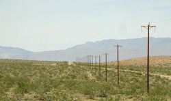 It was 2:35 pm now, and we had 16 more miles to get to the start of the road up to Lookout City. At this rate, it would mean nearly 3 more hours of driving, and I wanted to allow at least another hour to drive up to Lookout, so I decided that we had to take a faster road or camp down here in the valley. The map showed a crossroad off this road that would take us to the parallel (new) Nadeau Rd, that we passed just 500 feet behind us, so we drove back to it. To my surprise (and relief, considering the late hour) the Nadeau Rd was paved! We called it a Greenshit paved road though, because, except for that pavement, it was not built up at all and had no shoulders, so it felt as primitive and remote as the old road. It was 2:35 pm now, and we had 16 more miles to get to the start of the road up to Lookout City. At this rate, it would mean nearly 3 more hours of driving, and I wanted to allow at least another hour to drive up to Lookout, so I decided that we had to take a faster road or camp down here in the valley. The map showed a crossroad off this road that would take us to the parallel (new) Nadeau Rd, that we passed just 500 feet behind us, so we drove back to it. To my surprise (and relief, considering the late hour) the Nadeau Rd was paved! We called it a Greenshit paved road though, because, except for that pavement, it was not built up at all and had no shoulders, so it felt as primitive and remote as the old road.
In the next 17 minutes on this road, we averaged 6 times faster: 35 mph! I believe the pavement eventually ended and it turned into a dirt road, but it was still very smooth and flat, very well maintained. Alas, we were soon forced to turn off : the Nadeau Road we needed to take veered off to the right, becoming a primitive dirt road again, just as bad as the first 6 mph road, while this smooth road (also called the Nadeau Road on maps) went straight NW into the mountains to a working limestone quarry in the Argus Range. The new Nadeau Road was apparently paved and maintained only for the benefit of that quarry. At 2:55 pm, this meant we still had 6.5 miles to go on a very slow dirt road (an expected hour of driving), and some in our group were getting restless, with talk about stopping soon to camp. : the Nadeau Road we needed to take veered off to the right, becoming a primitive dirt road again, just as bad as the first 6 mph road, while this smooth road (also called the Nadeau Road on maps) went straight NW into the mountains to a working limestone quarry in the Argus Range. The new Nadeau Road was apparently paved and maintained only for the benefit of that quarry. At 2:55 pm, this meant we still had 6.5 miles to go on a very slow dirt road (an expected hour of driving), and some in our group were getting restless, with talk about stopping soon to camp.
I had my heart set on spending 2 nights at Lookout City though, so I felt it was worth trying to make it there tonight rather than camping for one night down here and then packing up again the next morning. I figured one hour on this road plus one hour to Lookout would mean arriving before 5:00 pm. Indeed, it took us almost an hour, until 3:50 pm, to go the 6.5 miles to the base of Lookout Mountain. At this point we turned left off the Nadeau Rd., expecting to be on the road up the mountain, but after going almost a mile on this side road I realized we were heading around the south side of Lookout Mountain, into Thompson Canyon , instead of Stone Canyon on the north side, so we had to turn back. In fact, this side road was heading to the defunct Minietta Mine , instead of Stone Canyon on the north side, so we had to turn back. In fact, this side road was heading to the defunct Minietta Mine , by which is one of those desert Adopt-a-Cabins. But we didn’t want to camp near that mine, either, and that 1-mile detour cost us another 15 minutes. (Later, reading in the Digonnet book, I found that this mine would have been a good destination in itself.) The actual turn , by which is one of those desert Adopt-a-Cabins. But we didn’t want to camp near that mine, either, and that 1-mile detour cost us another 15 minutes. (Later, reading in the Digonnet book, I found that this mine would have been a good destination in itself.) The actual turn to Lookout Mountain was at the very same intersection off the Nadeau Rd. as the Minietta Mine Road, but it was a gradual left instead of the hard left we took. This was confused by the fact that part of this road was also a landing strip, which looks better than any road but goes nowhere. to Lookout Mountain was at the very same intersection off the Nadeau Rd. as the Minietta Mine Road, but it was a gradual left instead of the hard left we took. This was confused by the fact that part of this road was also a landing strip, which looks better than any road but goes nowhere.
At 4:06 pm we were finally driving up the correct side road into Stone Canyon, beneath Lookout Mountain to our left, gently ascending into the Argus Range. While just beginning the ascent we passed by the large concrete pad 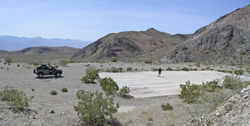 (about 50'x100') where Joey and I played Frisbee on our 2005 trip in Joey’s H2 Hummer. (We never figured out the purpose of that pad.) Continuing our ascent in the canyon, we passed by the campsite at the side of the canyon where Joey and I stayed for a night. (about 50'x100') where Joey and I played Frisbee on our 2005 trip in Joey’s H2 Hummer. (We never figured out the purpose of that pad.) Continuing our ascent in the canyon, we passed by the campsite at the side of the canyon where Joey and I stayed for a night. 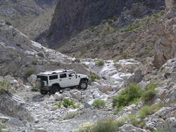 We camped there in 2005 because, having just one vehicle, we were cowed by an intimidating steep rocky section just beyond. But while camped, two old guys in another H2 just like Joey’s showed up, with the intent to go up to Lookout City that evening. They made it but needed our guidance getting up those rocks to avoid hubcap damage. We camped there in 2005 because, having just one vehicle, we were cowed by an intimidating steep rocky section just beyond. But while camped, two old guys in another H2 just like Joey’s showed up, with the intent to go up to Lookout City that evening. They made it but needed our guidance getting up those rocks to avoid hubcap damage.
This time, feeling a sense of impunity with 2 capable vehicles, my adrenaline was pumping for an all-out assault on those rocks. But when we got there, it was wimpy! Someone had fixed it, so dramatically that I couldn’t even tell where the bad spot was! Adrenaline, wasted.
The road up the canyon from here was slow, but easy. A half hour into the canyon, it seemed to end abruptly in a high, scenic, dry waterfall . But the road seemed to continue left around the side. However, immediately after this, we reached a dead end: the road kept going, but there was a Wilderness Area sign blocking access. Most of the upper Argus Range is in fact wilderness. Bummer! I couldn’t believe Lookout City had been closed to vehicles, as it was not in the wilderness area. But studying the landscape and the maps a bit, I decided that maybe there was still another way up to Lookout City, so we went back parallel to the canyon on another primitive road, up on the south wall just a little higher than the bottom of the canyon we had been on. Soon it was clear that this was the correct road to Lookout City. We had missed it by going straight up the canyon, instead of turning left a few hundred feet before the waterfall. . But the road seemed to continue left around the side. However, immediately after this, we reached a dead end: the road kept going, but there was a Wilderness Area sign blocking access. Most of the upper Argus Range is in fact wilderness. Bummer! I couldn’t believe Lookout City had been closed to vehicles, as it was not in the wilderness area. But studying the landscape and the maps a bit, I decided that maybe there was still another way up to Lookout City, so we went back parallel to the canyon on another primitive road, up on the south wall just a little higher than the bottom of the canyon we had been on. Soon it was clear that this was the correct road to Lookout City. We had missed it by going straight up the canyon, instead of turning left a few hundred feet before the waterfall.
In a half mile from this turn, 5 minutes after the wilderness sign, we arrived at a saddle, the crest of the ridge connecting Lookout Mountain to the Argus Range. This was at 3920', a 1500' gain from the Nadeau Rd. The road skirted around to the right of this ridge and descended slightly, to where it went along the main ridge to Lookout Mountain. In another 10 minutes and 0.7 miles, dropping 200' in elevation, we reached the ruins of what we thought was Lookout City at 4:54 pm., almost exactly the predicted 2 hours from the point where we left the New Nadeau Road.
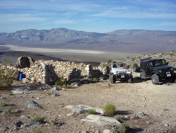 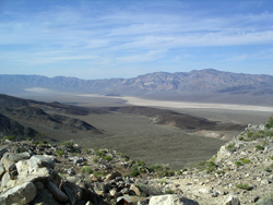 The site contained ruins of several buildings, with some complete stone walls standing. There was no wood or other debris visible—just the stone walls. From this location, we had sweeping views The site contained ruins of several buildings, with some complete stone walls standing. There was no wood or other debris visible—just the stone walls. From this location, we had sweeping views in three directions, including Panamint Valley and the Panamint Mountains beyond it and the Slate Range to the south. In the fourth direction behind and above us was the Argus Range. To the north we could see Lake Hill and the Panamint Dunes, 15 miles away, and 19 miles to our south was the Slate Range Crossing where we came from. As I hoped, this was an astounding campsite for a 2-night stay. in three directions, including Panamint Valley and the Panamint Mountains beyond it and the Slate Range to the south. In the fourth direction behind and above us was the Argus Range. To the north we could see Lake Hill and the Panamint Dunes, 15 miles away, and 19 miles to our south was the Slate Range Crossing where we came from. As I hoped, this was an astounding campsite for a 2-night stay.
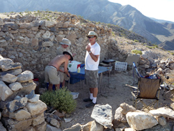 We immediately got to work setting up camp. We placed our kitchen right inside one of the ruins, which consisted of one high wall and 3 partial walls plus a doorway. The wall was in just the right position to shade the kitchen this time in the afternoon. We all claimed our sleeping areas nearby, setting up our ground cloths and bags, with Morrie attempting to sleep by an outside wall of the kitchen for wind protection. We immediately got to work setting up camp. We placed our kitchen right inside one of the ruins, which consisted of one high wall and 3 partial walls plus a doorway. The wall was in just the right position to shade the kitchen this time in the afternoon. We all claimed our sleeping areas nearby, setting up our ground cloths and bags, with Morrie attempting to sleep by an outside wall of the kitchen for wind protection.
At one point someone noticed a piece of metal stuck in one of the tires. Joey pulled it out with pliers: it was a large staple with 1" long points. The staple did not puncture the tire though, so all’s well. Such are the dangers of driving around old mine sites. Our camp was mostly set up and ready for use by 6:00 pm.
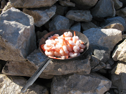 The first order of business at camp is always margaritas, which Joey prepared (as he was to do most days of this trip). Somehow Morrie managed to pour about ¼ oz of margarita in his hat, but this seemed good. We got out the first night’s appetizer, shrimp with cocktail sauce, but the shrimp were frozen hard in a solid block, so we put them in a pan in the sun on top of the rock wall. Then Joey couldn’t find the cocktail sauce, and because he had done shopping days ago, he couldn’t specifically remember whether he actually bought it (though it was on the shopping list). Desperate, the four of us spent 15 minutes looking high and low for the cocktail sauce, but no luck. Since shrimp are primarily a vehicle for cocktail sauce, this was threatening to be our first major disaster of the trip. As a last resort we decided that salsa would make reasonable cocktail sauce. (Later at the end of the trip, we found the cocktail sauce: it was in the bottom of one of the boxes underneath another bottle, so at least Joey’s shopping skills are vindicated, if not his memory.) The first order of business at camp is always margaritas, which Joey prepared (as he was to do most days of this trip). Somehow Morrie managed to pour about ¼ oz of margarita in his hat, but this seemed good. We got out the first night’s appetizer, shrimp with cocktail sauce, but the shrimp were frozen hard in a solid block, so we put them in a pan in the sun on top of the rock wall. Then Joey couldn’t find the cocktail sauce, and because he had done shopping days ago, he couldn’t specifically remember whether he actually bought it (though it was on the shopping list). Desperate, the four of us spent 15 minutes looking high and low for the cocktail sauce, but no luck. Since shrimp are primarily a vehicle for cocktail sauce, this was threatening to be our first major disaster of the trip. As a last resort we decided that salsa would make reasonable cocktail sauce. (Later at the end of the trip, we found the cocktail sauce: it was in the bottom of one of the boxes underneath another bottle, so at least Joey’s shopping skills are vindicated, if not his memory.)
The shrimp were still too frozen to eat at 6:40 pm, but it was at least possible to split them apart a bit, so we saw light at the end of our appetizer tunnel. We then took out the buffalo burgers for dinner, but they, too, were frozen solid, so we also put them on top of the rock wall in the sun. These were so frozen it seemed like thawing would take hours.
While sitting, sipping margaritas and smoking cigars, we watched some beautiful evening shadows on the hundreds of small rolling hills down in Panamint Valley. We could also see the silhouette of the Argus Range along the length of the valley, shading half the valley. Being high up, we remained in the sun for all of this. 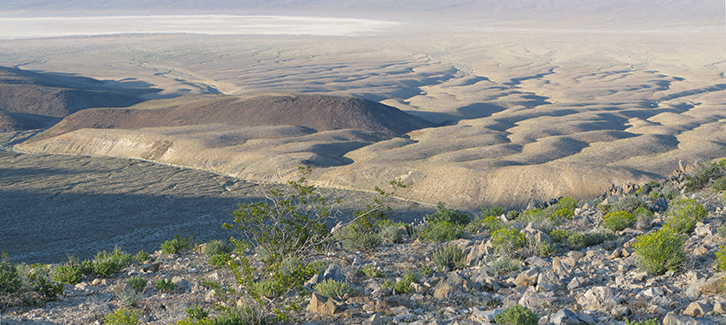
For much of the early evening we heard periodic gunshots from down in Thompson Canyon, 1000' below us to the south, possibly from the area of the Minietta Mine and the Adopt-a-Cabin. With binoculars we could see a car next to a building that was probably the cabin. At 7:00 pm, while finally eating our shrimp with salsa (which was every bit as good as shrimp with cocktail sauce) we heard a ricochet that couldn’t have been more than 50' from us, hitting something or whistling through the air. It was clearly a stray bullet and quite scary. So we yelled down into the canyon while Joey blew his ear-piercing whistle several times. It seems unlikely that anyone could hear us from that distance, but perhaps this worked because we didn’t hear any more shots after that.
The buffalo burgers finally thawed and we cooked them over charcoal in an aluminum fire pan. Bobby complained bitterly about the lack of ketchup. It wasn’t on the list (previously vetted by all) so nobody should have expected it, but Bobby said that in the past we always had ketchup, even though it was never on the list. Bobby was probably right, but I claimed responsibility only for the list, not the shopping. The lack of ketchup became a repeating theme on this trip, even threatening to spill into future trips, endangering the long-standing first- and second-place themes of Tom’s ground cloth and Danny’s Circus Fun cereal. cereal.
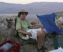 Anyway, we had the buffalo burgers on buns with mayonnaise, onion, lettuce, tomato (alas little micro-slices of grape tomato because the list did not indicate the tomatoes should be big), and of course jalapeno slices. We also had a big salad with raspberry-free dressing (yet another repeating theme) and a cup of boxed Merlot. Anyway, we had the buffalo burgers on buns with mayonnaise, onion, lettuce, tomato (alas little micro-slices of grape tomato because the list did not indicate the tomatoes should be big), and of course jalapeno slices. We also had a big salad with raspberry-free dressing (yet another repeating theme) and a cup of boxed Merlot.
Tonight we were too pooped from the long day for our usual night hike, although we did wander a bit around the campsite with another beer. Later, we just sat around with shots of Laphroaig (second best to our usual Lagavulin (second best to our usual Lagavulin that, at $85 a bottle, had gotten too expensive) plus a square of dark chocolate, watching the thin 2-day-old crescent moon setting behind the hills to our southwest, with Venus immediately above it. While the sky was still light, we could easily see the dark side of the moon, and as we watched the moon descend toward the Argus crest, I thought there was a good chance that the bright crescent of the moon might go behind the ridge before the dark part. I was curious how it would look to see only the dark part of the moon over the ridge. In fact, the moon moved more parallel to the ridge, so both dark and light portions began setting together. However because the moon was moving nearly parallel to the ridge, the moonset was very slow and drawn out. This was lucky, because a chance alignment of the ridge and the moon at 8:45 pm enabled us to see, for a couple of minutes, much of the dark portion of the moon grazing the ridge while the crescent was blocked. The ridge itself was glowing from moonlight and possibly reflecting light from Venus above it. It looked like a patch of snow with an eerie, angelic glow. that, at $85 a bottle, had gotten too expensive) plus a square of dark chocolate, watching the thin 2-day-old crescent moon setting behind the hills to our southwest, with Venus immediately above it. While the sky was still light, we could easily see the dark side of the moon, and as we watched the moon descend toward the Argus crest, I thought there was a good chance that the bright crescent of the moon might go behind the ridge before the dark part. I was curious how it would look to see only the dark part of the moon over the ridge. In fact, the moon moved more parallel to the ridge, so both dark and light portions began setting together. However because the moon was moving nearly parallel to the ridge, the moonset was very slow and drawn out. This was lucky, because a chance alignment of the ridge and the moon at 8:45 pm enabled us to see, for a couple of minutes, much of the dark portion of the moon grazing the ridge while the crescent was blocked. The ridge itself was glowing from moonlight and possibly reflecting light from Venus above it. It looked like a patch of snow with an eerie, angelic glow.
There was a brief panic that evening as we could not figure out how to divide 24 squares of chocolate (3 bars, each with 8 squares) in a way that would give us chocolate for 7 nights, until we decided we could live without chocolate the last night.
At 9:30 pm, as I was entering my sleeping bag, some large bug—perhaps a grasshopper—landed on me and then flew away. Spooked, I set up my sleeping bag screen tent, though I probably didn’t really need it. 
|