|
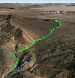 We awoke at 6:45 am, and at 61° it was just cool enough to wear long sleeves and pants. Breakfast included eggs and bacon, and just before 8:00 am Bobby had his first beer. While a planned 6.6-mile round trip hike would normally be long for us, as typical hikes go, I expected it would be easy this time: it was on an abandoned road and gained less than 400' in elevation. We awoke at 6:45 am, and at 61° it was just cool enough to wear long sleeves and pants. Breakfast included eggs and bacon, and just before 8:00 am Bobby had his first beer. While a planned 6.6-mile round trip hike would normally be long for us, as typical hikes go, I expected it would be easy this time: it was on an abandoned road and gained less than 400' in elevation.
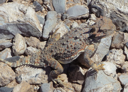 I don’t why it took so long, but we didn’t start hiking until 10:00 am. We walked on the closed road nearly due east from our campsite, and indeed it was easy walking. It began in a small canyon but at 10:24 am broke out into a very broad canyon—more like wash, actually. Behind us we could still see the summit with the cairn we had reached last night. The wash got so broad it became a shallow valley in a wide open desert. There were lots of nice flowers along the trail, and we also got a close view of a horned lizard. I don’t why it took so long, but we didn’t start hiking until 10:00 am. We walked on the closed road nearly due east from our campsite, and indeed it was easy walking. It began in a small canyon but at 10:24 am broke out into a very broad canyon—more like wash, actually. Behind us we could still see the summit with the cairn we had reached last night. The wash got so broad it became a shallow valley in a wide open desert. There were lots of nice flowers along the trail, and we also got a close view of a horned lizard.
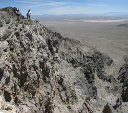 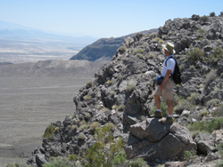 After a total hour and a half of hiking we could tell we were approaching the edge of a cliff, and at 11:47 am we reached the very edge After a total hour and a half of hiking we could tell we were approaching the edge of a cliff, and at 11:47 am we reached the very edge . It was a spectacular view of the Amargosa desert ½ mile below us, with a jagged, 2000' drop nearly straight down, then tapering to a gradual slope another 400' to the flats and the Nevada border about 4 miles away. We could see many more miles in the distance to mountains out of the range of our maps. . It was a spectacular view of the Amargosa desert ½ mile below us, with a jagged, 2000' drop nearly straight down, then tapering to a gradual slope another 400' to the flats and the Nevada border about 4 miles away. We could see many more miles in the distance to mountains out of the range of our maps.
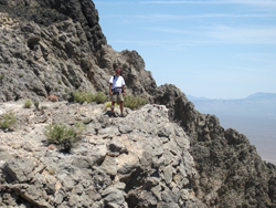 We spent nearly an hour wandering around along the top, admiring the view and getting queasy stomachs as we looked down the cracks between the ragged rocks. We stopped at a somewhat overhung spot for a lazy lunch in the sun. We spent nearly an hour wandering around along the top, admiring the view and getting queasy stomachs as we looked down the cracks between the ragged rocks. We stopped at a somewhat overhung spot for a lazy lunch in the sun.
At 12:37 we turned back. On the way we saw more nice flowers and had some fun with dodder moustaches.  Despite a very pokey pace we were back to our campsite at 2:25. Not counting the lunch stop, the 6.6-mile hike took only 3½ hours, close to a speed record for us, though we never felt like we were hurrying. Probably the 15-mile Telescope Peak hike of 2006 was the only time we hiked faster than this. Despite a very pokey pace we were back to our campsite at 2:25. Not counting the lunch stop, the 6.6-mile hike took only 3½ hours, close to a speed record for us, though we never felt like we were hurrying. Probably the 15-mile Telescope Peak hike of 2006 was the only time we hiked faster than this.
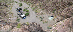 About an hour later, while others were relaxing, I took a 10-minute hike up to an overlook directly north and above our campsite, so I could get a panorama shot. From here I saw the ridge continue to a rounded summit further north. About an hour later, while others were relaxing, I took a 10-minute hike up to an overlook directly north and above our campsite, so I could get a panorama shot. From here I saw the ridge continue to a rounded summit further north.
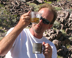 At 5:14 Joey was preparing margaritas. Our appetizer was a jar of Trader Joe’s jalapeno-stuffed olives, but they were somewhat of a disappointment, so vinegary that we couldn’t even finish them. With olives in his mouth Joey used a hypodermic needle to puncture a blister on his toe. Our supper was angel hair pasta with pesto, capers, mushrooms, and parmesan cheese. I think we eschewed the jalapenos for this meal but I can’t be certain of that. At 5:14 Joey was preparing margaritas. Our appetizer was a jar of Trader Joe’s jalapeno-stuffed olives, but they were somewhat of a disappointment, so vinegary that we couldn’t even finish them. With olives in his mouth Joey used a hypodermic needle to puncture a blister on his toe. Our supper was angel hair pasta with pesto, capers, mushrooms, and parmesan cheese. I think we eschewed the jalapenos for this meal but I can’t be certain of that.
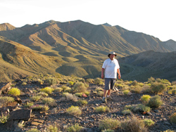 I suggested for an evening hike that we go up to that summit that I saw from the overlook. We started at 6:39 and got to that point at 7:04. It was a 400' ascent, but it wasn’t really a summit—just the first bump on a ridge with many bump beyond. In fact we could I suggested for an evening hike that we go up to that summit that I saw from the overlook. We started at 6:39 and got to that point at 7:04. It was a 400' ascent, but it wasn’t really a summit—just the first bump on a ridge with many bump beyond. In fact we could 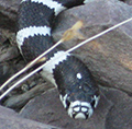 tell the ridge kept going and going for a very long time, so we didn’t go much farther. Near the top of this hike Bobby almost bumped into a black and white striped snake, about 3' long, that I had never seen before. We didn’t know what it was but I didn’t think it was poisonous. Later I found out it was a California king snake tell the ridge kept going and going for a very long time, so we didn’t go much farther. Near the top of this hike Bobby almost bumped into a black and white striped snake, about 3' long, that I had never seen before. We didn’t know what it was but I didn’t think it was poisonous. Later I found out it was a California king snake . From our high point we could easily see the cairn across the valley where we hiked the night before, and the beautiful evening shadows of the ridge on the valley floor. Here Danny also added a rock or two to a small cairn. We turned around a couple of minutes later and were back at camp after a total of 55 minutes and ¾ mile. . From our high point we could easily see the cairn across the valley where we hiked the night before, and the beautiful evening shadows of the ridge on the valley floor. Here Danny also added a rock or two to a small cairn. We turned around a couple of minutes later and were back at camp after a total of 55 minutes and ¾ mile. 
|