|
Most of us were up around 7:30 am, a pretty late arousal. 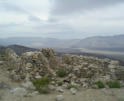 There was little or no wind all night, so we had a great sleep. The morning was overcast, with some threatening weather in the north over Panamint Dunes. Breakfast was a mixture of eggs and swiss cheese, mushrooms, onions, and jalapenos plus bacon on the side. At 9:41 am after breakfast we had our eye opener (a shot of top shelf tequila with salt and lime). This was the first morning we had to pack up, so it took quite a while deciding how to arrange stuff, and we weren’t ready to drive until 11:49 am. By this time the sun was starting to come out from the clouds, with the gloomy weather fading. There was little or no wind all night, so we had a great sleep. The morning was overcast, with some threatening weather in the north over Panamint Dunes. Breakfast was a mixture of eggs and swiss cheese, mushrooms, onions, and jalapenos plus bacon on the side. At 9:41 am after breakfast we had our eye opener (a shot of top shelf tequila with salt and lime). This was the first morning we had to pack up, so it took quite a while deciding how to arrange stuff, and we weren’t ready to drive until 11:49 am. By this time the sun was starting to come out from the clouds, with the gloomy weather fading.
Driving back along the ridge we had some nice views of Thompson Canyon and back to Panamint Valley. At 12:23 pm, now back down in Stone Canyon, we stopped to take some pictures of the jeep with the sway bar disconnected, because it looks like the front axle is falling off. 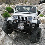 Ideally, this requires a section of road where just one front wheel drops into a hole, but the best we could do is raise one front wheel above the others. At 1:06 pm, as we came out of Stone Canyon, we stopped briefly by a pretty nice mine. We walked into a shaft about 50' and came to a sudden wall. There was enough natural light to see the whole length of it. Ideally, this requires a section of road where just one front wheel drops into a hole, but the best we could do is raise one front wheel above the others. At 1:06 pm, as we came out of Stone Canyon, we stopped briefly by a pretty nice mine. We walked into a shaft about 50' and came to a sudden wall. There was enough natural light to see the whole length of it.
At 1:20 we passed by another mine entrance in the wall up to the right. Four minutes later we were at the big concrete pad again, looking for a Frisbee opportunity. We decided the pad was too small for 4 people, but there was a flat area right across from it. We played about 20 minutes in some strong winds that made it pretty challenging, but at the end when we decided we would stop after 4 catches in a row, we actually got 8.
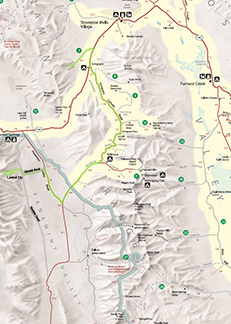 We drove the rest of the way toward the Nadeau Road, went back south on the Nadeau Road for 1/3rd mile, and then turned left (east) onto the Minietta Road. In 15 minutes and 3.6 miles later, we reached the paved Panamint Valley Road. We had to go south on this road 6.5 miles to get to the Trona-Wildrose Road, which would take us to Emigrant Canyon Road and the high country. Because our tires were aired down, I decided we should stay under 50 mph on paved roads. In 9.6 miles at 2:41 pm we passed by the Charcoal Kiln Rd. in the Wildrose area that goes up to Mahogany Flat, a destination for a Telescope Peak visit. The elevation here was 4040' and it was pretty cool, and it was getting cooler as we ascended. The road, though still paved, was very scenic. At 3:00 pm we reached the height-of-land at 5395', and it was quite cold. The road to Wood Canyon was just 1.7 miles further and still over 5000', so it didn't promise to be much warmer. This cold considerably dampened our enthusiasm for camping near here. The Tucki Mine Road further down began much lower, but then ascended to a rather high elevation as well, so I didn’t expect to be any better. We drove the rest of the way toward the Nadeau Road, went back south on the Nadeau Road for 1/3rd mile, and then turned left (east) onto the Minietta Road. In 15 minutes and 3.6 miles later, we reached the paved Panamint Valley Road. We had to go south on this road 6.5 miles to get to the Trona-Wildrose Road, which would take us to Emigrant Canyon Road and the high country. Because our tires were aired down, I decided we should stay under 50 mph on paved roads. In 9.6 miles at 2:41 pm we passed by the Charcoal Kiln Rd. in the Wildrose area that goes up to Mahogany Flat, a destination for a Telescope Peak visit. The elevation here was 4040' and it was pretty cool, and it was getting cooler as we ascended. The road, though still paved, was very scenic. At 3:00 pm we reached the height-of-land at 5395', and it was quite cold. The road to Wood Canyon was just 1.7 miles further and still over 5000', so it didn't promise to be much warmer. This cold considerably dampened our enthusiasm for camping near here. The Tucki Mine Road further down began much lower, but then ascended to a rather high elevation as well, so I didn’t expect to be any better.
I decided, therefore, that our best chances for warmth were to go to Lemoigne Canyon, where we could camp at 2000', which would be much warmer, and save Wood and Tucki for another hotter trip. (Greenshit 2010a subsequently made it to Tucki.) Also, we had never been to Lemoigne, and it presented a good opportunity for a 2-night stay. But since it was getting late and I read that the Lemoigne Canyon Road was in terrible shape, we didn’t have time to see Skidoo or Aguereberry Point. Yet more stuff for another trip.
So we drove another 13 miles beyond Wood Canyon, passing some nice pinnacles, to the end of the Emigrant Canyon Road where it hits CA 190, and then 3 miles north on CA 190 to the Lemoigne Canyon Road, which we reached at 3:33 pm. In retrospect we could have gotten to this intersection from Lookout much earlier by going straight north to 190 from the Trona-Wildrose Road, had we known warmth would be an issue.
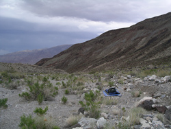 The books were certainly right about the condition of the Lemoigne Canyon Road. It was not difficult, dangerous or steep, but extraordinarily bumpy with gullies and washes every few feet. It was necessary to stay in 4L, first gear, for the first 2 miles of this road, where we averaged only 5 mph. This was slower progress than the Old Nadeau Road two days earlier. It got slightly better the rest of the way, but all together this 5.3-mile road took us 55 minutes. (Curiously the park maps show this road is only supposed to be 4.4 miles long, but we didn’t encounter a barrier until 0.9 miles later.) We reached the end of the road and our campsite at 4:30 pm, much later than I would have liked. But it was a nice spot with good views and both day and night hiking opportunities, so I knew we would be happy here for 2 nights. The books were certainly right about the condition of the Lemoigne Canyon Road. It was not difficult, dangerous or steep, but extraordinarily bumpy with gullies and washes every few feet. It was necessary to stay in 4L, first gear, for the first 2 miles of this road, where we averaged only 5 mph. This was slower progress than the Old Nadeau Road two days earlier. It got slightly better the rest of the way, but all together this 5.3-mile road took us 55 minutes. (Curiously the park maps show this road is only supposed to be 4.4 miles long, but we didn’t encounter a barrier until 0.9 miles later.) We reached the end of the road and our campsite at 4:30 pm, much later than I would have liked. But it was a nice spot with good views and both day and night hiking opportunities, so I knew we would be happy here for 2 nights.
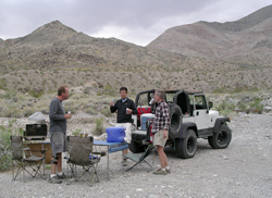 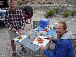 It was overcast now, and at 2800' it was still cool enough to wear long sleeves, but not uncomfortable. It would have been at least 15° cooler at the originally planned campsites. Dinner this night was Tom’s memorial macaroni and cheese and Smokey Links, although Joey can never find Smokey Links in the store, so we had to settle for some other kind of hot doggish meat. We also added onions and jalapenos, and had asparagus spears as a side (I think). It was overcast now, and at 2800' it was still cool enough to wear long sleeves, but not uncomfortable. It would have been at least 15° cooler at the originally planned campsites. Dinner this night was Tom’s memorial macaroni and cheese and Smokey Links, although Joey can never find Smokey Links in the store, so we had to settle for some other kind of hot doggish meat. We also added onions and jalapenos, and had asparagus spears as a side (I think).
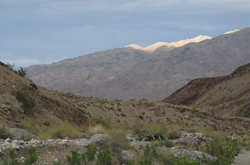 At 7:30 pm we saw some beautiful lit up hills in the fading sunlight. At 7:42 pm we were ready for a night hike (though it was still not dark) up a side canyon At 7:30 pm we saw some beautiful lit up hills in the fading sunlight. At 7:42 pm we were ready for a night hike (though it was still not dark) up a side canyon heading to the left (southwest) from our campsite. We went quite a way as night hikes go: 1.8 miles round trip in a little over 2 hours, a vertical ascent of about 350'. It was a pretty interesting slot canyon, maybe 20' wide and at least 20' high, and we turned around only because we felt we had gone far enough for an evening. This might be a canyon to explore further on a day trip. Along the way we took some night pictures of us in a hole in the wall. We were back at camp just before 10:00 pm, when we had our Laphroaig and chocolate and went to bed. It was very cool by bedtime. heading to the left (southwest) from our campsite. We went quite a way as night hikes go: 1.8 miles round trip in a little over 2 hours, a vertical ascent of about 350'. It was a pretty interesting slot canyon, maybe 20' wide and at least 20' high, and we turned around only because we felt we had gone far enough for an evening. This might be a canyon to explore further on a day trip. Along the way we took some night pictures of us in a hole in the wall. We were back at camp just before 10:00 pm, when we had our Laphroaig and chocolate and went to bed. It was very cool by bedtime. 
|